Enregistrez gratuitement cette image
en 800 pixels pour usage maquette
(click droit, Enregistrer l'image sous...)
|
|
Réf : T02607
Thème :
Terre vue de l'espace - Villes (375 images)
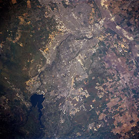
Titre : Sacramento, California, USA April 1998
Description : (La description de cette image n'existe qu'en anglais)
Sacramento, California, USA April 1998 Folsom Lake (dark feature at lower left) was created by damming the North Fork and South Fork of the American River northeast of Sacramento, capitol of California. The American River (dark, meandering band) then continues southwestward through the urban landscape (dense concentration of lighter colors), finally joining the Sacramento River near downtown Sacramento. Rice, wheat, corn, and a variety of vegetables are grown on the large cultivated fields north and west of the city. Segments of Interstate Highway 80 (light linear feature west of Folsom Lake) are visible as the highway enters the urban area. Several airport runways, including McClellan Air Force Base (northeast of downtown), Sacramento Metropolitan Airport (northwest), and Cameron Park Airport (east) are also visible. The greenish undeveloped grasslands east of Sacramento are the western foothills of the Sierra Nevada
|
|

